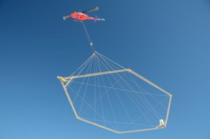
WATEC holds advanced research expertise and optimal research facilities for the testing and development of novel methods and technologies in the area of "Water mapping and modelling".
Hydro Geophysics – Mapping and modelling
The HydroGeophysics Group at Institute of Geoscience, Aarhus University, is part of WATEC Aarhus University Centre for Water Technology.
Mapping of groundwater and modelling groundwater flow and interaction with surface water at the catchment scale are central research themes in the HydroGeophysics Group.
The HydroGeophysics Group develops mapping technology bridging advances in electronics design and high performance computing to achieve advanced and integrated resource modelling.
Applications are worldwide and range from local scale point source contaminations to catchments covering thousands of square kilometers.
Modelling of aquatic ecosystems
WATEC is also engaged in development and application of models for managing and understanding the function of aquatic ecosystems.
This includes development of state-of-the-art process-based models and novel approaches such as ensemble simulations and assimilation of real-time data into aquatic ecosystem models.
Several research projects are on going e.g. high-frequency data from sensors to become assimilated into model simulations allowing testing of the effects on model performance.
